Our hiking tips
Here you can find our personal hiking tips from the surrounding area.
Starting point: Biovita Hotel Alpi
At a glance: Biovita Hotel Alpi – Monte Elmo cable car mountain station – Rif.Gallo Cedrone – „Sillianer Hütte“ – „Hornischeck“ – Alpe-Nemes – „Froneben“ – Biovita Hotel Alpi
Difference in altitude: about 600 m and 1295 m in descent
Pure walking time: 7 – 8 hours
Trail lenght: approx. 20 Kilometer
Difficulty: 5-mountain shoe hike
Route description: First we take the Monte Elmo cable car up to the mountain station (2041 m). From there we go eastwards via the Rif.Gallo Cedrone (2150 m) to the “Sillianer Hütte” (2447 m) and cross the “Hochgrubengipfel” (2537 m), from where you can descend early to the Biovita Hotel Alpi.
The path 403 then crosses or bypasses the Hornischeck (2550 m) and the “Hollbrucker Spitze” (2581 m) to the “Hochgräntenjoch” (2429 m; also here at the war cemetery it is possible to descend into the valley) and finally the “Demutspitze” (2591 m), the “Schöntalhöhe” (2634 m) and the two summits of the “Eisenreich” (2665 m), from where we descend to the western “Obstanser Sattel” (2533 m). Here a signpost points to the left to the “Obstanser See” hut (2304 m), but we leave the ridge to the right, descend on trail 160 southwestward to the “Knieberg saddle” (2325 m) and from there again to the right on trail 146 further to the Nemes alp (1877 m, bar). Now on trail 13 and 139 out of the valley to the “Froneben” Inn (1540 m) and back to the Biovita Hotel Alpi.
Tips and special notes: Very long, but not difficult and scenically magnificent hike over the Carnic ridge. The marked high-altitude trail, which requires endurance, leads in repeated ups and downs always over the course of the ridge and also crosses several peaks; here and there a little lake pleases our eye. The tour offers a splendid view of the mountains of South and East Tyrol and especially of the Sesto Dolomites. On the ridge you will still encounter many remains from the First World War, a war cemetery and other border buildings. The trail runs partly in Italy and partly in Austria.
Summary: you have a unique 360 ° panoramic view – after the „Sillianerhütte“ the tour becomes lonely and you have “your peace”. If you descend to the „Obstanserseehütte“, you should be early enough, because you have to calculate at least 45 min in the arrival – and descent.
Starting point: Biovita Hotel Alpi
At a glance: Biovita Hotel Alpi-Rif.Fondovalle-„Zsigmondyhütte“ –„Büllelejochhütte“-„Dreizinnenhütte“-„Talschlusshütte“
Difficulty in altitude: 1158 m
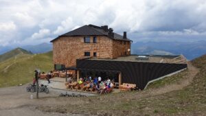
Highest point: „Büllelejochhütte“ (2528 m)
Pure walking time: 6 to 7 hours
Lenght: approx. 13 kilometers
Difficulty: 5-mountain shoe hike
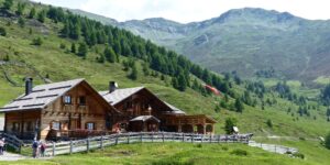
Route: First by bus or car (45 minutes on foot) to the Val Fiscalina to the parking lot at “Dolomitenhof” (1454 m). From there almost level to the Rif.Fondovalle (1548 m) and right on trail 102/103 in the “Altensteintal briefly” up to a trail division.
Here turn left and follow path 103 high above the valley bottom of the “Bachern valley” up to the “Zsigmondy hut” (2235 m; magnificent view of the “Elferstock and Zwölfer”).
From the refuge now on the high-altitude trail marked with No. 101 over rocky ground partly slightly ascending westward to the “Oberbachernjoch” and to the right to the “Büllelejochhütte” (2528 m). Shortly continue to the “Büllelejoch” (2522 m), on the north side over scree steeply down a bit and then in a nice, even hike with a view to the “Dreischusterspitze” to the big “Dreizinnenhütte” at the “Toblinger Riedl” (2438 m). Wonderful view of the Three Peaks.
From the hut now on trail 102 northeastwards over the Bödenalm with the two upper lakes and then through the wildly beautiful “Altensteintal valley”, which is overlooked in the south by the mighty structure of the “Einserkofel”, down to the Rig.Fondovalle in the Val Fiscalina valley and back to the starting point.
Tips and special notes: The scenically magnificent high-altitude trail connects the „Zsigmondyhütte“ with the „Dreizinnenhütte“, which offers the famous view of the grandiose north faces of the Three Peaks.
Halfway along the trail, the „Büllelejochhütte“ is a pleasant place to stop for refreshments. The easy but long hike is first dominated by the mighty „Zwölferkofel“ and later by the „Paternkofel“, which gained fame in the First World War through the heroic death of Sepp Innerkofler. If, according to the weather forecast, the afternoon clouds over, the reverse circuit allows a clear view of the Three Peaks in the morning.
Summary: an absolute classic and a must for every visitor to Sesto to stand in front of the north walls of the most beautiful mountain in the Dolomites.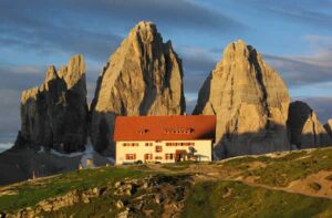

Starting point: Moos/Biovita Hotel Alpi
At a glance: Biovita Hotel Alpi – Val Fiscalina – heads of Croda Rossa – Croda Rossa – Bad Moos – Biovita Hotel Alpi
Difference in altitude: 350 m and 865 m in descent
Highest point: heads of Croda Rossa 2.235 m
Pure walking time: 4-5 hours
Trail lenght: approx. 8 kilometers
Difficulty: 3-mountain-shoe-hike
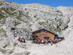
Route: From the Biovita Hotel Alpi at the church turn right to Café Kofler, continue through the meadows to the valley station of the Croda Rossa and take the cable car up to the Croda Rossa. Past the “Rudihütte”, take the upper 100 path (past the mountain station of the small drag lift), which leads to the heads of Croda Rossa. Via a beautiful path through the rocks, which is, however, a bit exposed, we reach the “Anderter Alpe”, where the open-air museum “Bellum Aquilarum 1. World War I” is also located.
Here you should plan some time for the open-air museum but also for the wonderful panoramas around. At the fork in the road, we follow trail 122 down into the Fiscalina Valley for a short distance until we reach another fork in the road, where we follow trail 124 to the right, level high above the Fiscalina Valley out of the valley.
We reach a fork in the path, where we turn right back to the Rotwand meadows (cable car descent), but we descend steeply to the left over dense forest into the Fiscalina valley and back to Moos and the Biovita Hotel Alpi.
Tips and special advice: It needs a little head for heights and surefootedness. The hike is very varied, i.e. from straight to steep paths in the rocks and places with steep slopes. Again and again the path grants you spectacular views. The hike can alternatively be done as a shorter round trip starting from the Rotwandwiesen and back again or as a longer round trip with ascent and descent to the Fischleintal (without cable car).
Summary: a round hike in a class of its own, where a bit of a head for heights is also required.
Starting point: Moos/Biovita Hotel Alpi
At a glance: Biovita Hotel Alpi – „Froneben“ – „Klammbachalm“ – „Nemesalm“ – „Coltrondo-Alm“ – „Schwarzsee“ – Biovita Hotel Alpi
Difference in altitude: 509 m
Highest point: „Klammbach Alm“ (1.944 m)
Walking time: 6 hours
Trail lenght: approx. 14 kilometers
Difficulty: 4-mountain-shoe-hike
Route: From the Biovita Hotel Alpi hike in the direction of Berghotel Tirol, from dorf the trail leads uphill and reaches the mountain inn “Froneben” (1540 m) turning right at the first fork. Now we hike on trail 139 across the high moor “Obere Oltl” to trail no. 13, a forest road. This now leads us through dense spruce forests along the gorge of the Sesto stream. At a fork near a high crossroads we turn left and hike on the wide path 133 northwards up to the Klammbachalm with its unforgettable view (1944 m; bar); from the starting point 2 hours. From the Klammbachalm we hike along the scenic trail no. 13 in a long slope crossing south-eastwards to the Nemes or Sextner Alm (1877 m; bar). All around, in front of the magnificent backdrop of the Sesto Dolomites, there are extensive alpine pastures. Via path no. 156 we continue south-eastwards, first descending briefly and then crossing wooded slopes, to the Coltrondo alpine pasture (1879 m). From there we take the path towards the Kreuzberg Pass and follow the corresponding signposts (Mark. 149). We pass through extensive woods and, after crossing a forest ridge, we turn right (Mark. 130) and pass by the small Schwarzsee (1741 m). Finally, we walk down to the camping “Patzenfeld” and return to the starting point via trail 13 A or 1.
Tips and special advice: No car is necessary for this long, but not difficult circular hike; because of the dense network of paths, but a good hiking map! From the Coltrondo Alm directly to the Kreuzbergpass and from there by bus to Moos – time saving about 45 min. – The tour can also be done in the opposite direction, reaching the Kreuzbergpass by bus and thus saving about 300 meters in altitude. The tour can also be shortened to one or two alpine pastures.
Summary: a wonderful panoramic tour, where you constantly have the imposing mountains of the Sesto Sundial in front of your eyes.
Cozy places to stop for refreshments along the way.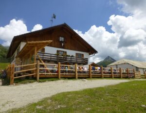
Starting point: Moos/Biovita Hotel Alpi
At a glance: Biovita Hotel Alpi-„Festung Haideck“-„Fischleintalwiesen“-„Innergsellwiesen“–„Außergsell“-Sesto -Biovita Hotel Alpi
Difference in altitude: approx. 730 m
Highest point: „Innergsell“ (2065 m)
Walking time: 5 hours
Trail lenght: approx 12 kilometers
Difficulty: 3-mountain-shoe-hike
Route: Starting from Moos (1339 m), we cross the valley floor westward, reach the ruins of the old barrier fort „Haideck“ (1413 m) in a short ascent and cross the forest and meadow slopes southward following the mark 1 A to the junction with trail 12. Now on this trail steeply up through the forest, over the „Bärisbach“ and further up until the forest thins out. A fountain there bears the inscription “All the waters of the earth sing the song of joy”, and it is truly a pleasure to quench one’s thirst here. A little later we cross the water valley and come to a crossroads. Now we climb steeply on the left in several turns on the shady forest path to the first mountain meadows and on a narrow path up to the highest point of the Innergsell meadows, the “Rossehimmel” (2065 m; Innergsell). From there you have a magnificent view of the immense mountain scenery of the Sesto mountain sundial, the central Alps and the Sesto and Puster valleys. – Then we briefly descend westwards on footpath 12, cross the scree slope below the Gsellknoten and reach the Außergsell (2004 m) with the meadows of the same name and a private hut in a short counter ascent. – The descent leads first along a wide path (forest road) nr. 12 to a flat bottom, where path 12 B branches off towards the east down to the meadows called “Frohne” and across them to Sesto, from where we return to the starting point.
Tips and special notes: The „Gsellwiesen“, accessible on easy, albeit sometimes steep paths, are an insider tip for nature lovers and those seeking peace and quiet, also because there is no managed hut there. They spread out on the slopes of two almost equally high mountain peaks that rise southwest above Sesto under the mighty mountain structure of the „Dreischusterspitze“.
Summary: Quiet – solitude and silence coupled with magnificent panoramas. Food must be taken along, as there is no managed hut.
Starting point: Biovita Hotel Alpi
At a glance: Biovita Hotel Alpi – Sesto – Forest chapel – „Mitterberg/Panorama“ – Biovita Hotel Alpi
Difference in altitude: approx. 300 m
Highest point: „Holzer Hof“ – „Außerbacher“ 1600 m
Pure walking time: 2,5 – 3 hours
Trail lenght: approx. 7 kilometers
Difficulty: 3-mountain shoe hike
Route: From the Biovita Hotel Alpi (1370 m) turn right uphill to the Sesto circular trail no. 1 and follow it to the left out of the valley towards the church in Sesto. Here, at a wooden fountain in front of the “Goldenes Kreuz” in, the path of contemplation begins (mountain path marking 4 D) past the stations of the cross and the “Hösler and Ladstätter” farms to the forest chapel, which is extremely scenic. The forest chapel is hidden in a piece of forest with a special and mystical atmosphere and served as a hiding place for holding German church services during the fascist era. From here continue until the path joins a forest road (marker 4), follow this to the junction of path 2 and then continue to the Waldruhe inn (beautiful terrace) – there a short tarred section left up to the “Holzerhof (Auserbacher)” and continue along a charming narrow path to the “Mitterberg – Panorama” inn. Continue following trail no. 3 down past the hut of the legendary Knödelweibele and back along the Sesto circular trail (trail no. 1) to the Biovita Hotel Alpi.
From Gasthof Panorama there is the possibility of a variant back via “Helmhanghütte – Troyer Höfe” – Biovita Hotel Alpi.
Tips and special hints: This simple but beautiful and varied trail runs in the 1st section on the Sesto circular path, then past the famous Sesto cemetery begins the path of reflection to the forest chapel. From there a short forest section always on the sunny side of the Sesto Valley with beautiful views back to the Biovita Hotel Alpi.
Summary: Culture – a special and mystical atmosphere-, old Sesto farms and great views of the Sesto sundial.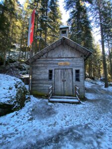
Starting point: Moos/Biovita Hotel Alpi
At a glance: Biovita Hotel Alpi – Croda Rossa – Passo Monte Croce – Biovita Hotel Alpi
Difference in altitude: approx. 50 m & 600 in descent
Highest point: approx. 2000 m
Pure walking time: 5 hours
Trail lenght: approx. 13 kilometers
Difficulty: 2-mountain shoe hike
Route: From the Biovita Hotel Alpi to the church in Moso we walk to the right to Café Kofler and further through the meadows to the valley station of the Croda Rossa cable car (about 10 minutes). Then we take the cable car up to the beautiful Croda Rossa (1950; refreshments available). Our now following hiking route is well marked with 15. The trail first crosses the flat clearing of the Croda Rossa meadows, then briefly sparse forest and then it moves under the bizarrely shaped rock formations of the Croda Rossa, the Niner and the “Arzalpenkopf”, partly over wide scree cirques, partly through beautiful mountain forest to the ridge descending from the Arzalpenkopf to the Passo Monte Croce. All along the route you can see remains from the First World War, especially on the “Arzalpenkopf”, which is completely riddled with caverns and tunnels (interwar period). You follow this ridge for a short time, after which a short descent along the ski slope over meadows leads down to the Passo Monte Croce (1636 m). From there the descent (if we do not use the public bus) leads us through sparse forest slightly descending along path no. 13 A to the “Signaue” and finally along the Sesto circular path (no. 1) directly back to the starting point.
Tips and special notes: cenically extremely beautiful, six-kilometer-long high-altitude trail that follows old war trails and can be recommended even to less experienced mountain hikers, especially since the ascent can be done by lift and the way back by bus. The good path goes from the Rotwand meadows partly at the timberline, partly above it at the foot of vertical rock falls almost flat to the Kreuzberg pass. From the path beautiful views to the Carnic ridge and to the north to the ice peaks of the „Riesefernergruppe“.
Summary: an easy and scenic tour with little difference in altitude between the tree line and the rocks with many remnants of the 1st World War.
Starting point: Moso/Biovita Hotel Alpi
At a glance: Biovita Hotel Alpi – „Bruggerlift“ – Signaue –Croda Rossa valley station – „Festung Haideck“ – Sesto – „Kinigerhöfe“ – Biovita Hotel Alpi
Difference in altitude: approx. 150 m
Highest point: Signaue (1.443 m)
Pure walking time: 3 hours
Trail lenght: approx. 8,5 kilometers
Difficulty: 1-mountain-shoe-hike
Route: The entire trail is marked with the number 1! From the Biovita Hotel Alpi the trail leads uphill to the right, right over the bridge and then at the “Brugger lift “right off a small narrow path along the edge of the forest to the forest road to the “Nemesalm”. We follow this for a short distance and turn right again onto the first forest road, past a bee house and a “Einödhof” through a short section of forest and after a change of direction we reach the Signaue and the Hennstall hut. This coincides with the path that leads to the Kreuzberg pass. Here turn right over the bridge and back to the eastern end of Moos, crossing the street Passo Monte Croce and continuing into the Fiscalina valley to the valley station of the Croda Rossa cable car. Here, take the 102 path into the Fiscalina valley for a short distance and then turn right at the path pillar and you will reach the upper meadow path. Follow this out of the valley in a westerly direction to “Haideck Fortress”, which was totally destroyed in World War I and now only remains exist. There continue slightly descending until in a sharp bend on the left a small forest path leads further out of the valley to Sesto. There we cross the main road, change the side of the valley and reach the “Kinigerhöfe” on the helmet side of the valley of Sesto on a hill. Between these two farms slightly above, the path leads along the edge of the meadow back to Moos and the Biovita Hotel Alpi.
Tips and special remarks: a short but very nice hike that is ideal to explore our valley and to get a very good first impression. A half-day tour that is very suitable for a rest day or with children. The path is very nicely laid out and in between there are always explanations and interesting plants.
Summary: a small but nice round tour to explore the Sesto Valley and a beautiful walk also doable in sections.
Starting point: Moos/Biovita Hotel Alpi
At a glance: Biovita Hotel Alpi – „Froneben“ – „Wegkreuzung Saumahd“ – „Seikofel“– „Schwarzsee“ – Camping – Biovita Hotel Alpi
Difference in altitude: 540 m
Highest point: Seikofel 1.908 m
Walking time: 4 hours
Trail lenght: approx. 9 kilometers
Dificulty: 3-mountain shoe hike
Route: From the Biovita Hotel Alpi hike up to the Berghotel Tirol and from there the trail leads uphill and reaches the mountain inn Froneben (1540 m) turning right at the first fork. Now we hike on trail 139 across the high moor “Obere Oltl” to trail no. 13, a forest road. This now leads us through dense spruce forests along the gorge of the Sesto stream. At a fork in the road shortly after a high wayside cross (1,756 m – Wegkreuzung Saumahd) we turn right (shortly before this we turn left to the Klammbach Alm) and enter the forest on a wide forest road. We follow this forest road briefly and reach a large clearing. Here the path 132 branches off to the left and leads to the Seikofel (1,908 m), past beautiful high moors, rare plants and animals. Some of the ponds are the result of shell impacts from the 1st World War, where the Seikofel, because of its strategic position and its magnificent panoramic view, was a hotly contested place. From the Seikofel we descend to path 131, which leads from the Nemesalm to the Passo Monte Croce. We follow this and reach a depression and then a hill. Here several paths meet and one can calmly speak of a crossroads. We take the wide forest road (path no. 130), which leads away to the right to the Schwarzsee. Shortly after the small lake, which is also located in a high moor, the path turns left and leads quite steeply downhill, past the campsite and continues downstream in the Sesto circular path (no. 1). We now follow the Sesto circular trail, which leads us back to the Biovita Hotel Alpi.
Tips and special notes: A beautiful and not too long hike that leads through the silent world of the high moors. The Seikofel is also a refuge of the capercaillie and other game species, and therefore it is essential to be considerate of them. Stay on the paths and keep quiet. Because of the dense network of paths, you need a good hiking map! Especially the turnoff to the Schwarzsee is a bit tricky. Provisions must be brought along, or the first stop is the campsite.
Summary: a very beautiful panoramic tour that takes us away from the crowds into a small natural paradise. Noise and shouting have lost nothing at the Seikofel.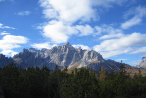
Starting point: Moos/Biovita Hotel Alpi
At a glance: Biovita Hotel Alpi – Croda Rossa valley station – Croda Rossa – Biovita Hotel Alpi
Difference in altitude: approx. 70 m
Highest point: 1.970 m
Pure walking time: approx. 1 hour
Trail lenght: approx. 2 kilometers
Difficulty: 1-mountain-shoe-hike
Route: From the Biovita Hotel Alpi the path leads to the church in Moos. There turn right to Café Kofler and along the meadow path to the valley station of the Rotwandwiesen cable car at the entrance to the Fischlein valley. The cable car takes you comfortably up to the Rotwandwiesen. Here in the family and nature paradise at 1,900 m, the family circular hiking trail marked with No. 19 begins on the left and ends at the same place. The nice little path goes up and down through the undergrowth and on the way you will encounter a poacher’s cave, many cozy resting places, a witch’s hut and also a place to picnic invites you to stay.
Tips and special notes: This is a wonderful walk for families with children, but also without children absolutely worth seeing and suitable to spend a leisurely day on the mountain meadows. The trail is very varied and offers many interesting rest stops. On the way there is also a nice picnic area.
Summary: a wonderful easy hike, which completes the offer of the children – and family paradise Rotwandwiesen. You can also continue from there via path no. 18 without difficulty to the Kreuzbergpass and return home by bus or on foot along the stream.